When Extreme Weather Meets Parched Earth: The American Southwest Grapples with El Niño’s Deluge And Drought Paradox

A powerful and destructive weather system tore across the American Southwest last weekend, leaving communities submerged, infrastructure overwhelmed, and at least four people dead. While moisture is an invaluable and scarce commodity in the arid desert climates of Arizona, New Mexico, Utah, and Colorado, the region received two to three months’ worth of average rainfall in just a matter of days. The staggering deluge exposed the limitations of human infrastructure, which is ill-equipped to handle massive, compressed volumes of water in a region defined by historical dryness.
The storm was part of a broader, volatile autumn weather pattern that climatologists say has been supercharged by an unfolding El Niño event. According to data from the National Oceanic and Atmospheric Administration (NOAA) and regional climate centers, the anomalies in atmospheric and oceanic conditions have set the stage for a turbulent winter across the southern tier of the United States. While water managers and conservationists welcome the prospect of drought relief, the immediate aftermath has underscored the severe hazards of sudden, extreme precipitation on sun-baked and drought-weakened terrain.
A Chronology of Extreme Deluges
The recent catastrophes are the culmination of a wet and increasingly erratic autumn across the Southwest. The pattern began building in earnest in late September, when atmospheric rivers and slow-moving storm systems locked into place over the region.
On September 20, an extraordinary atmospheric disturbance dropped an unprecedented 28.84 inches of rain on Clovis, New Mexico, over a brief period—shattering the city’s historical average of just 3.3 inches for that timeframe. This initial saturation set a dangerous precedent, leaving soils completely waterlogged and riverbeds running at unusually high levels for the early fall season.
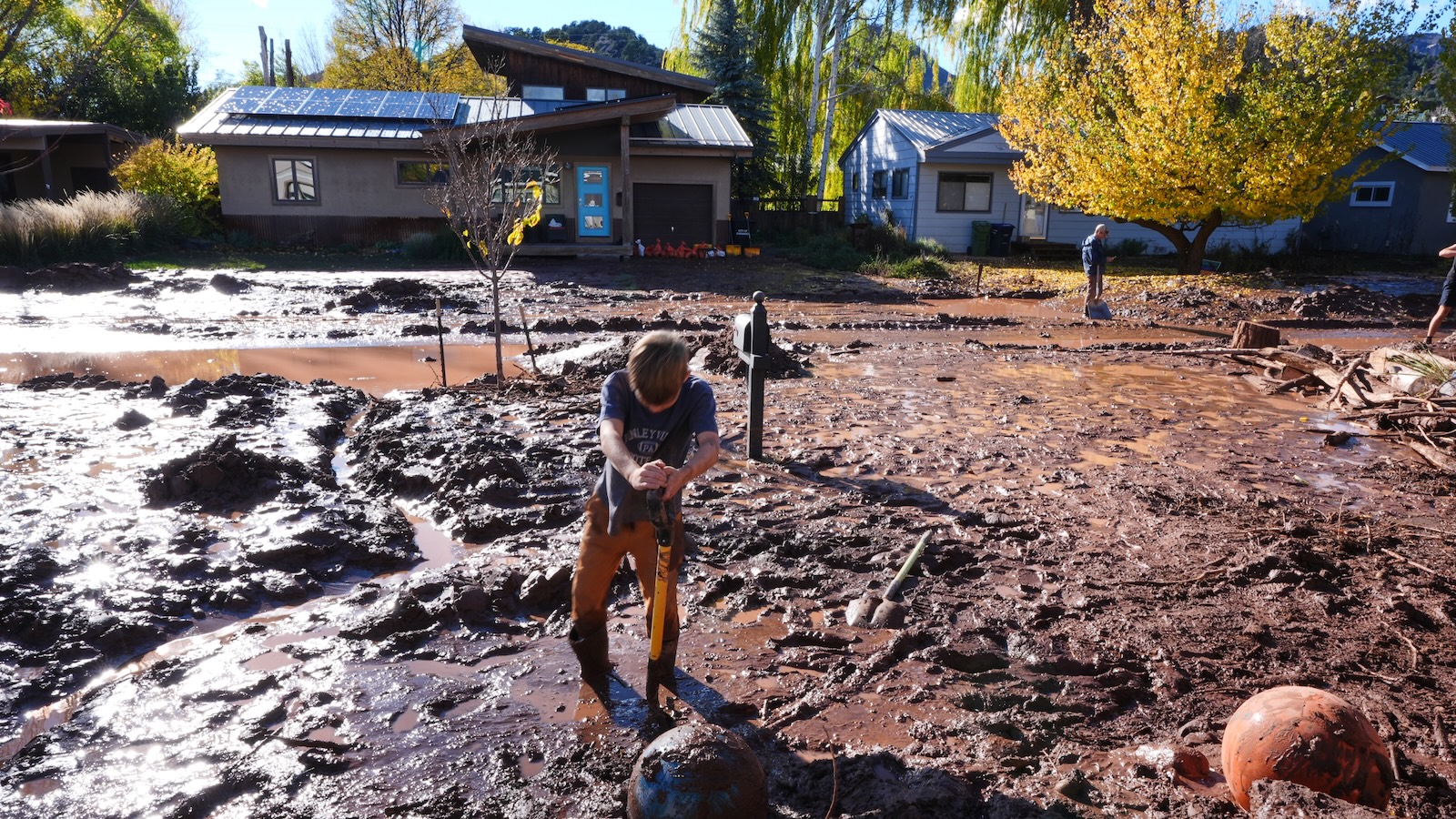
Just weeks later, in late October, a separate, highly concentrated storm system slammed into Colorado, cementing its place in the state’s historical records. Higher elevations in Southwest Colorado received up to eight inches of rain over a grueling four-day period. The resulting flash floods caused widespread destruction, washing out roads, destroying bridges, and trapping residents.
The compounded effect of these successive storms culminated in last weekend’s ferocious weather event. Because the ground was already completely saturated from the September and October downpours, the latest round of heavy rain could not be absorbed by the earth. Instead, it instantly transformed into destructive runoff, swelling local rivers and streams past their banks and triggering catastrophic flash floods across Arizona, Colorado, Utah, and New Mexico.
The El Niño Factor and Ocean Heat Content
Climatologists tracking the unfolding weather patterns point directly to the Pacific Ocean as the primary engine driving these extreme events. The current El Niño phenomenon—characterized by a persistent band of unusually warm water along the equatorial Pacific—is already registering as one of the strongest on record, with projections indicating it could intensify further over the coming months.
Although a temperature variance of just a few degrees might seem negligible, this massive pool of warm water injects immense thermal energy into the global atmosphere. This atmospheric disruption alters jet stream configurations, scrambling weather patterns worldwide. The influence of this El Niño is so profound that it has exerted a direct suppression on tropical storm formation in the Atlantic basin by introducing strong, disruptive wind shears high in the atmosphere.
Consequently, the 2026 Atlantic hurricane season shattered records for the latest first hurricane in a season by nearly a month. In a typical year, the Atlantic would have generated roughly six tropical cyclones by this point in the calendar; however, 2026 has produced only a single hurricane in that basin.
Conversely, the Pacific Ocean has picked up the slack. Abnormally high ocean temperatures—exacerbated by human-induced climate change, which has caused the world’s oceans to absorb more than 90 percent of excess atmospheric heat—have fueled an active eastern Pacific hurricane season, producing 10 hurricanes to date. The excess heat and moisture generated by these warm Pacific waters are the exact ingredients feeding the atmospheric rivers targeting the American Southwest.
Topography and the Mechanics of Flash Floods
The geography of the Southwest makes it uniquely vulnerable to catastrophic flash flooding when atmospheric moisture levels spike. Mountainous terrain, canyons, and steep arroyos act as natural funnels, gathering massive amounts of rainfall and accelerating it into violent, fast-moving torrents.
Experts note that the landscape of the Southwest is a testament to the immense power of water over geological timescales. Geomorphologists studying the region point to massive, out-of-place boulders scattered across desert floors and mountain foothills as physical evidence of ancient, colossal floods. While those historical events may have occurred thousands of years ago, the underlying topographical mechanics remain unchanged. When extreme volumes of water are dumped onto steep, impermeable mountain slopes, the resulting flash floods can materialize with terrifying speed and destructive force.
Furthermore, the sequential nature of this autumn’s storms created a worst-case scenario for hydrological response. Russ Schumacher, the state climatologist and director of the Colorado Climate Center at Colorado State University, emphasized that the timing of the weather systems was critical. When a second major storm follows closely on the heels of a record-breaking deluge, the landscape lacks any remaining capacity to absorb precipitation. Every additional drop becomes immediate runoff, exponentially increasing the severity of downstream flooding.
Economic and Infrastructure Implications
The repeated battering of Southwestern infrastructure has forced municipal leaders, emergency management agencies, and civil engineers to reassess how communities prepare for and respond to extreme weather. Traditional flood control infrastructure—such as concrete-lined channels, dams, and stormwater drainage systems—was largely designed for historical rainfall distributions rather than the intense, highly concentrated precipitation events driven by a warming climate.
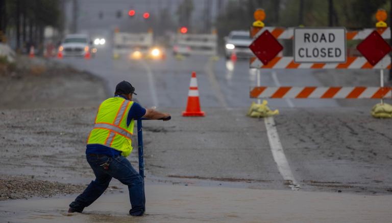
When communities receive two to three months of rain in a matter of days, urban drainage systems quickly fail, leading to widespread property damage, stranded motorists, and costly emergency rescues. In rural and mountainous areas, damaged transportation corridors sever supply chains, isolate small towns, and disrupt regional commerce. The economic toll of repairing roads, bridges, public utilities, and residential properties places a heavy burden on local and state budgets.
The Drought Paradox: A Complex Water Reality
Despite the immediate devastation and loss of life caused by the recent storms, water resource managers are analyzing a complex silver lining: the potential for long-term drought relief.
The American Southwest has endured a decades-long megadrought, intensified by rising global temperatures that increase evaporation rates from reservoirs, rivers, and soil. At the same time, rapid population growth across states like Arizona, Nevada, and Utah has placed unprecedented demands on a shrinking water supply. Consequently, the Colorado River’s two largest storage vessels, Lake Powell and Lake Mead, have hovered near dangerously low levels, prompting warnings of potential system collapse.
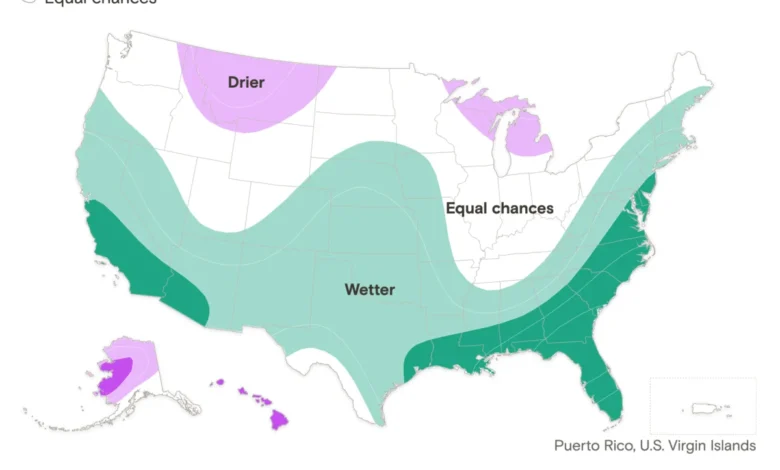
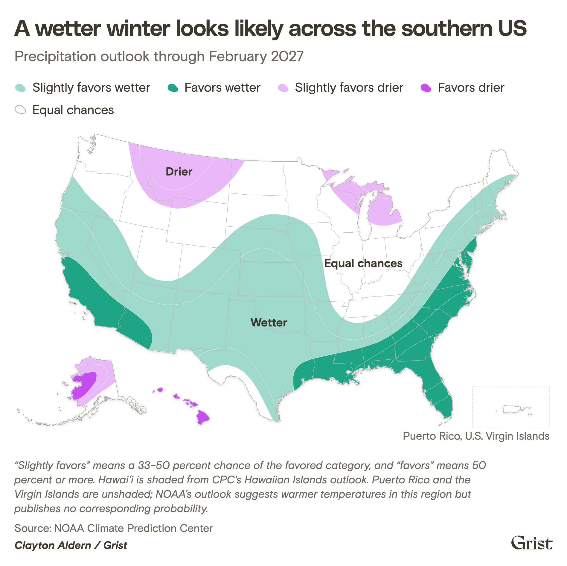
NOAA’s seasonal winter outlook indicates that the ongoing El Niño event favors increased precipitation across the southern tier of the United States through February 2027. This wetter pattern is projected to improve or entirely alleviate drought conditions across much of the Southwest, the Southern Plains, and parts of the Southeast.
However, climate scientists caution that while a wet winter can provide a temporary reprieve, it cannot permanently reverse the structural decline of the region’s water systems. Filling depleted reservoirs requires not just a single stormy season, but a multi-year recovery of both winter snowpack and consistent watershed replenishment. Schumacher noted that the region has a long way to go to return even to the baseline conditions of a decade ago, let alone the robust water levels seen in the latter half of the 20th century.
The Wildcard of Winter Snowpack
As the region transitions from autumn into winter, attention turns to the mountains of Colorado, Utah, and New Mexico, and the looming question of snowpack accumulation.
Unlike autumn rainfall, which runs off immediately and overburdens flood control infrastructure, high-altitude snowpack acts as a natural, frozen reservoir. Winter snow accumulates slowly on mountain peaks and releases its water content gradually during the spring and summer thaw, feeding the Colorado River and local watersheds in a measured, manageable way.
Following a winter that produced record-low snowpack levels across parts of the Rocky Mountains, the region enters the cold season with an urgent need for substantial snowfall. Whether the El Niño pattern delivers heavy mountain snow or instead brings warmer storms that produce rain at higher elevations will dictate the state of Southwestern water supplies for the remainder of the decade.
Shifting Paradigms in Water Management
Recognizing that climate change will continue to drive weather extremes—oscillating between severe droughts and torrential deluges—water agencies and municipal planners are shifting their approach to stormwater management.
Rather than viewing stormwater purely as a nuisance or an emergency threat to be rushed out of urban areas as quickly as possible, forward-thinking cities are reimagining rain as a valuable resource. In Arizona, municipalities such as Tucson have invested heavily in green infrastructure initiatives. By constructing bioswales, rain gardens, and engineered earthen basins designed to capture runoff and hydrate native vegetation, these cities are slowing the velocity of stormwater while simultaneously recharging local aquifers.
These decentralized, nature-based engineering solutions cannot prevent the catastrophic impacts of multi-inch regional rainstorms overnight, but they represent a crucial adaptation strategy. By working with the natural topography rather than strictly against it, Southwestern communities are slowly learning how to survive—and occasionally harvest—the excess bounty of a changing climate.