FireSat Constellation Deploys, Offering New Hope in Global Wildfire Battle Amidst Escalating Climate Crisis

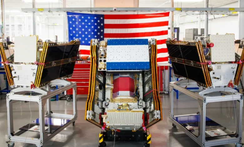
As smoke from hundreds of burning wildfires continues to spread across Canada and the United States, cloaking major cities in hazardous haze, a significant technological advancement in wildfire detection has reached a critical milestone. The first three operational satellites in the Google-backed FireSat program successfully launched into orbit on July 7, 2026, aboard a SpaceX Falcon 9 rocket from Vandenberg Space Force Base in California. This deployment marks a pivotal transition to "initial operational capability" for the FireSat constellation, managed by the nonprofit Earth Fire Alliance. Following a rigorous three-month testing period, these microsatellites are slated to begin actively providing crucial wildfire detection data to fire agencies across the United States, Australia, and Europe before the end of the year, promising a new era in early fire detection and response.
A New Era in Wildfire Detection Technology
The FireSat program represents the first satellite constellation purpose-built exclusively for detecting wildfires, a critical distinction that allows it to overcome limitations inherent in existing general-purpose Earth observation satellites. Traditional satellites, while useful, often struggle with the specific challenges of wildfire detection, such as penetrating dense smoke plumes or identifying nascent fires before they escalate into uncontrollable infernos. FireSat’s specialized design, developed by California-based satellite manufacturer Muon Space, aims to fill this crucial gap.
Each FireSat satellite is equipped with advanced multispectral imaging capabilities, meticulously engineered to peer through thick smoke and cloud cover. This allows them to detect fires as small as five by five meters—approximately 16 by 16 feet—a capability far exceeding that of many current systems. The efficacy of this technology was conclusively demonstrated by a FireSat Protoflight satellite, which launched in March 2025. Over its operational period, the protoflight collected more than one million images, proving its ability to identify low-intensity blazes that remained invisible to existing satellite networks. This unprecedented sensitivity to heat signatures, even through atmospheric obscurants, is expected to revolutionize early detection efforts.
A Collaborative Endeavor: Funding and Partnerships
The ambitious FireSat initiative has garnered substantial financial and technical backing from leading philanthropic and technology organizations. Google has committed over $15 million to support the initial deployment and development of the constellation, underscoring its commitment to leveraging technology for climate resilience. The Bezos Earth Fund has also emerged as a significant supporter, committing a substantial $26 million to the program, recognizing its potential to address the global wildfire challenge. These investments highlight a growing recognition among major players in the tech and philanthropic sectors of the urgent need for innovative solutions to environmental crises.
The Earth Fire Alliance, a nonprofit organization, is at the helm of managing the FireSat constellation, ensuring its data is disseminated effectively to fire management agencies worldwide. This collaborative model, bringing together private sector innovation, philanthropic capital, and a dedicated nonprofit, exemplifies a multi-stakeholder approach to tackling complex global environmental problems.

Projected Impact and Ambitious Timeline
The launch of these initial satellites marks the beginning of an ambitious deployment schedule. After the three-month testing phase, the operational satellites will commence providing data, covering every fire-prone region on Earth at least twice per day. The "early adopter" organizations slated to begin utilizing FireSat data this year include critical fire agencies in California, Colorado, Australia, and Portugal—regions that have historically faced severe and devastating wildfire seasons.
The FireSat program’s long-term vision is even more expansive. As more satellites are launched, the constellation aims to provide the latest imagery anywhere in the world on an hourly basis by 2029. By the early 2030s, once the full constellation of more than 50 satellites is deployed, imagery is projected to be available every 20 minutes, offering near real-time intelligence to fire authorities. This level of constant surveillance could dramatically reduce response times and enable firefighters to contain fires before they grow into megafires.
The Earth Fire Alliance has presented compelling projections regarding the potential benefits of this enhanced detection capability. Even an hourly revisit rate by the FireSat constellation is estimated to help save more than $1 billion in fire damage costs annually. Furthermore, it could prevent nearly 22 million tons of carbon emissions by limiting the scale of wildfires, along with protecting approximately 3,500 homes and preserving 1.3 million acres of land from destruction. These figures underscore the profound economic, environmental, and social implications of timely wildfire detection.
AI at the Forefront of Wildfire Intelligence
Beyond mere detection, Google Research plans to integrate its advanced AI models with the operational FireSat data. This integration will involve using AI to compare real-time FireSat imagery with historical data, enabling highly accurate identification of even the smallest fires. Crucially, Google’s AI will also contribute to sophisticated predictive modeling of wildfires, helping agencies anticipate fire behavior, identify high-risk areas, and allocate resources more effectively.
In celebrating the launch of the first operational FireSat satellites, Google emphasized the event as "another tangible step forward in putting practical AI to work for climate resilience." This statement highlights the growing role of artificial intelligence not just in identifying problems, but in providing actionable insights that can inform proactive strategies to mitigate the impacts of climate change. The combination of cutting-edge satellite technology and advanced AI analytics is expected to create a powerful tool for global wildfire management.
The Intensifying Global Wildfire Crisis: A Broader Context

The urgency of the FireSat mission is underscored by the escalating global wildfire crisis, which has reached alarming proportions in recent years. The current situation in North America serves as a stark reminder. As of July 2026, smoke from hundreds of burning wildfires in Canada has once again generated smothering smoke clouds that have traversed vast distances, inflicting hazardous air pollution upon more than 100 million people across Canadian and US cities, from the Midwest to the Mid-Atlantic and Northeast. These events have forced thousands of people, particularly in vulnerable First Nations communities, to evacuate their homes, disrupting lives and livelihoods.
The scientific consensus is unequivocal: wildfires are burning with greater size, intensity, and frequency due to climate change. Greenhouse gas emissions from human reliance on fossil fuels continue to drive global warming, leading to hotter, drier conditions, extended fire seasons, and increased fuel loads in forests and grasslands. Werner Kurz, a retired senior research scientist at Natural Resources Canada, succinctly articulated the grim reality to The Atlantic: "What is unfolding is what climate and forest scientists have been predicting for 30 years. That as the world gets hotter and drier, we are exposing forests to more and more risk, and the old strategies of fire suppression are simply being overwhelmed."
Canada, a country with vast boreal forests, has experienced some of its most destructive wildfire seasons in recent memory. The years 2023 and 2025 were particularly severe, and the last three fire seasons collectively rank among the top 10 worst on record. As of July 17, the Canadian Wildland Fire Information System reported nearly 900 active wildfires across the country, with over 3,600 wildfires recorded year-to-date, burning more than 6.6 million acres—an area larger than several small European nations. Many of these are designated as "out of control" wildland fires, which are simply being monitored rather than actively suppressed. This difficult decision is often forced upon fire agencies due to limited resources, the remoteness of the blazes, and the imperative to protect firefighters’ lives.
Beyond Canada, similar trends are observed globally. Australia has endured devastating "Black Summer" fires, the Amazon rainforest faces increasing deforestation-driven blazes, and regions across Siberia and the Mediterranean are experiencing unprecedented fire activity. This global pattern underscores the systemic nature of the challenge FireSat aims to address.
Challenges Beyond Detection: Suppression and Resource Management
While early detection is paramount, it is only one component of a comprehensive wildfire management strategy. The ability to identify fires quickly must be paired with sufficient resources for effective suppression and proactive ecosystem management. Traditional fire suppression methods, such as deploying fixed-wing air tankers to drop fire retardants and heavy-lift helicopters to transport firefighting crews to remote sites, are becoming increasingly strained.
The burden of acquiring and maintaining such specialized firefighting aircraft often falls on individual Canadian provinces, leading to disparities in capacity. In recent years, virtually every available aircraft has been pressed into service, highlighting a systemic shortage. Recognizing this strain, the Canadian federal government took a proactive step in May 2026, leasing 10 new aerial firefighting aircraft and two support assets to augment nationwide response capacity, making them available as surge assets for provinces. However, even with these additions, the sheer scale and intensity of modern wildfires often overwhelm existing capabilities.
Furthermore, proactive measures like prescribed burns—controlled fires set to reduce fuel loads and promote forest health—are crucial for preventing catastrophic blazes. However, these practices often face logistical, regulatory, and public perception hurdles. The increasing severity of fire seasons means that fire agencies have fewer "windows" of opportunity to conduct prescribed burns safely, further exacerbating fuel accumulation.

The Paradox: AI’s Environmental Footprint
The enthusiasm surrounding AI-powered solutions for climate resilience, such as FireSat, is tempered by a growing awareness of the significant environmental footprint of the very technology underpinning these advancements. Silicon Valley’s rapid deployment of newer AI models has come with considerable climate costs, particularly in the form of massive energy consumption by AI data centers.
These data centers require enormous amounts of electricity, and much of this demand is currently being met by new natural gas projects in the United States. Projections indicate that the greenhouse gases emitted by this data center boom could collectively outpace the total emissions of entire nations, potentially releasing more than 129 million tons of greenhouse gases per year. Google itself has publicly acknowledged the formidable challenges of deploying enough clean energy projects to offset the rapidly increasing emissions from its energy-hungry data centers. In 2025 alone, Google’s company-wide electricity usage grew by a staggering 37 percent, largely driven by its aggressive AI buildout.
This presents a complex paradox: while AI offers powerful tools to combat the symptoms of climate change, its infrastructure simultaneously contributes to the problem. The development of sustainable AI, with a focus on energy efficiency and renewable energy sourcing for data centers, remains a critical area for innovation and responsible technological development.
A Multifaceted Future for Wildfire Management
The launch of the FireSat constellation represents a significant leap forward in humanity’s ability to detect and respond to wildfires. By providing unparalleled early detection capabilities and integrating advanced AI for predictive insights, FireSat offers a beacon of hope in a world increasingly grappling with the devastating impacts of climate change. However, as experts and policymakers emphasize, technological solutions, no matter how advanced, are but one piece of a much larger puzzle.
Effective wildfire management in the age of climate change requires a multifaceted approach: robust early detection systems like FireSat, adequate funding and resources for fire suppression, proactive ecosystem management through prescribed burns and forest thinning, and, fundamentally, aggressive global action to mitigate greenhouse gas emissions. Only through such comprehensive and integrated strategies can societies hope to adapt to and ultimately curb the escalating global wildfire crisis. The FireSat program, while a powerful tool, serves as a poignant reminder of both human ingenuity and the profound environmental challenges that demand collective, sustained effort.
Related posts: