The Environmental Catastrophe in the Strait of Hormuz: A Silent Casualty of the Eight-Month War

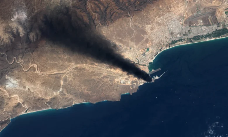
As the conflict between the United States and Iran enters its ninth month, the geopolitical consequences of the war have begun to manifest in an increasingly alarming theater: the ecological collapse of the Persian Gulf. Satellite imagery from November 2026 confirms that the Strait of Hormuz, the world’s most critical maritime chokepoint, is effectively blanketed in massive, persistent oil slicks. This environmental crisis, the result of more than 133 confirmed attacks on oil tankers and maritime infrastructure, has created a transboundary pollution event that experts suggest may haunt the region for decades.
The strategic importance of the Strait of Hormuz cannot be overstated. It serves as the primary artery for global energy supply, with millions of barrels of oil and liquefied natural gas passing through its narrow waters daily. However, since the outbreak of hostilities on February 28, 2026, this maritime passage has been transformed into a high-intensity battlefield. The resulting debris, sunken vessels, and spilled crude have combined to form a toxic layer that threatens to suffocate the unique, high-salinity ecosystem of the Gulf.
A Chronology of Escalation
The environmental degradation began almost immediately following the onset of the conflict in late February. By mid-March, initial reports of oil contamination emerged following strikes on Iranian naval vessels, specifically the Shahid Bagheri. These early spills set a precedent for the months to follow, as the war moved from land-based maneuvering to a systemic campaign of maritime attrition.
In April, the focus of the destruction expanded toward protected coastal zones, with incidents reported near Shidvar Island, a critical sanctuary for coral reefs and migratory seabirds. The intensity of the conflict hit a record peak in October 2026. According to the Washington Institute for Near East Policy, more than 30 separate attacks were recorded during this 31-day period alone. Among the most significant was the strike on the supertanker Gem No. 2 off the coast of the United Arab Emirates, which released a massive plume of crude oil that drifted for over 21 miles.
By November, the cumulative impact of these individual strikes has reached a scale that defies standard cleanup capabilities. Greenpeace estimates suggest that the combined footprint of these slicks covers approximately 20,000 square kilometers—an area roughly equivalent to the landmass of Wales.

The Ecological Fragility of the Gulf
The Persian Gulf is not a typical oceanic environment; it is a semi-enclosed, shallow basin with extremely high water temperatures and limited flushing capacity. These characteristics make it exceptionally vulnerable to chemical pollutants. Marine biologist Bernhard Riegl, who has conducted extensive research in the region for over three decades, notes that the Gulf’s shallow nature prevents the deep-water mixing that might otherwise dilute or disperse toxins.
"In the summer months, the atmospheric heat is directly transferred to the water column," Riegl explains. "This creates an environment where corals, fish, and algae are already operating at the edge of their thermal tolerance. When you introduce crude oil into this mixture, you are effectively poisoning a system that has no natural mechanism for recovery."
The damage extends far beyond the surface-level slicks visible from orbit. Mangrove forests, such as those near the Hara biosphere reserve, are highly susceptible to oil-coating, which clogs the pneumatophores—the root systems that allow these trees to breathe in anaerobic mud. When these forests die, they take with them the primary nurseries for regional fish populations, effectively collapsing the local food chain.
Data-Driven Analysis of the Spill
The scale of the pollution is currently being mapped through a combination of synthetic aperture radar (SAR) satellite imagery and oceanic current modeling. Greenpeace’s data monitoring center has identified over 500 distinct spill events since the start of the war. While some of these are minor, others represent "catastrophic releases" from hull ruptures on VLCCs (Very Large Crude Carriers).
- June 2026: A major strike off the coast of Oman resulted in a spill estimated at 230 square miles.
- August 2026: The sinking of the Liberian-flagged Minoan Pioneer released significant volumes of crude, with oil washing up on Qeshm Island, contaminating vital turtle nesting sites.
- October 2026: The Gem No. 2 incident, which triggered a major emergency response from the UAE to protect desalination infrastructure.
The difficulty in verifying the source of every spill is exacerbated by the naval blockade, which prevents independent observers from conducting physical water sampling. Furthermore, researchers in both Iran and neighboring Gulf states have reported pressure from domestic authorities to maintain silence regarding the extent of the environmental damage, suggesting that the true scale of the catastrophe may be significantly higher than current international estimates.
Geopolitical Responsibility and Official Responses
Attribution in this conflict remains a contentious issue. While the Islamic Revolutionary Guard Corps (IRGC) has been linked to the majority of attacks on tankers, US naval forces have also engaged in strikes against Iranian vessels, often citing the need to disable ships attempting to breach the blockade. Additionally, reports from the Wall Street Journal indicate that the UAE has conducted independent strikes on oil storage infrastructure, including facilities on Lavan Island, to disrupt Iranian logistics.

The response from regional governments has been largely reactive. In the UAE, emergency response teams were deployed following the Gem No. 2 strike to protect water treatment plants and sensitive shoreline assets. Oman has also attempted to deploy booms and skimmers in the Hallaniyat Islands. However, these localized efforts are described by environmental experts as "stop-gap measures" that are insufficient to address the systemic contamination of the seabed and intertidal zones.
Long-Term Implications and Historical Precedents
Historical data from the 1980s provides a grim outlook for the region’s recovery. Studies conducted decades after the Iran-Iraq War and the first Gulf War reveal that crude oil is not merely a temporary nuisance; it is a persistent contaminant. Research published in Science of the Total Environment in 2020 and subsequent studies in 2022 confirmed that tar deposits from the 1980s are still present in the sediment of beaches in Qatar and Saudi Arabia.
If these historical patterns hold, the 2026 conflict will result in a generational environmental burden. "Any organism that interacts with the substrate of the beach—be it sea turtles digging nests or ghost crabs burrowing—will be exposed to toxic residue," says Nina Noelle, an expert in environmental disaster relief. "We are looking at a scenario where the coastal ecosystem of the Gulf will be fundamentally altered for the next thirty to fifty years."
The loss of these habitats poses an existential threat to the economic future of coastal communities that rely on artisanal fishing and eco-tourism. As the war continues, the destruction of the maritime environment serves as a stark reminder of the "unclean" nature of modern conflict. While military commanders focus on the strategic utility of the Strait of Hormuz, the biological cost of the war is being paid by the species and habitats that define the region’s natural heritage. With no immediate end to the hostilities in sight, the "size of Wales" oil slick is likely to continue expanding, turning the Persian Gulf into a long-term toxic legacy of the 2026 war.