The Future of Wildfire Suppression: How Drones and Artificial Intelligence are Revolutionizing Forest Fire Response

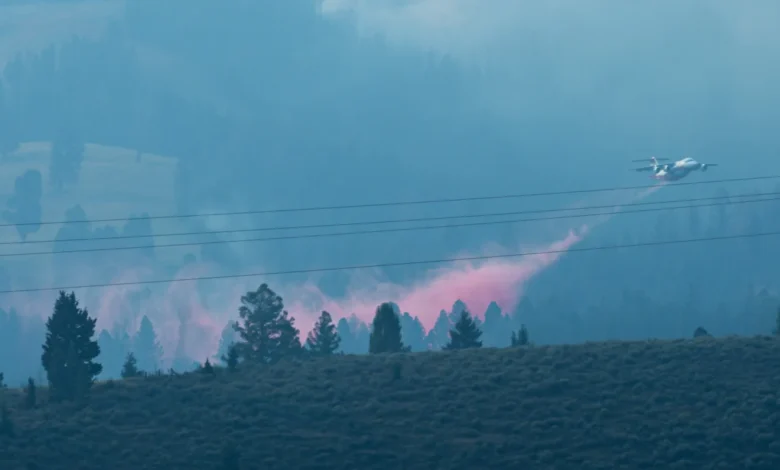
The Sand Creek Fire, which ignited in the rugged terrain of southwestern Montana in early August 2026, has served as a pivotal case study for the integration of unmanned aerial systems (UAS) and artificial intelligence in modern wildfire management. As the blaze tore through steep, inaccessible slopes, traditional manual surveillance proved both dangerous and inefficient. Fire crews, tasked with identifying smoldering embers within fire-weakened timber, faced significant physical risks. In response, federal fire managers pivoted to a high-tech approach, deploying drones to pinpoint heat signatures, map fire perimeters, and monitor conditions that would otherwise remain hidden from human observers. This operational shift represents a broader, systemic transition within the U.S. Forest Service and other firefighting agencies, marking a departure from purely manual combat tactics toward a future defined by autonomous support and predictive data analytics.
A Chronology of the Sand Creek Fire Response
The Sand Creek Fire began in August 2026, quickly establishing itself as a challenging incident due to the verticality of the Montana landscape and the density of the surrounding forest. By the second week of the blaze, fire commanders realized that standard aerial reconnaissance—typically conducted via manned aircraft—was hampered by intermittent visibility and the immense cost of keeping human-crewed planes in the air for prolonged monitoring.
By mid-August, the Forest Service had fully integrated drone modules into their tactical operations. These systems were not merely used for observation; they were utilized to conduct aerial ignitions—controlled burns designed to remove fuel from the path of the primary fire. By using drones for these high-risk operations, fire managers successfully reduced the exposure of ground crews and pilots to unpredictable fire behavior and hazardous smoke conditions. As the fire moved into its final stages of containment, drone teams became the primary method for "mop-up" operations, using thermal imaging to detect hotspots that could reignite if left unattended.
The Technological Arsenal: From Drones to Autonomous Ground Vehicles
The transition to technology-led firefighting extends well beyond the sky. The U.S. Forest Service is currently undergoing a rigorous evaluation phase for autonomous ground vehicles (AGVs) designed to operate in terrain where standard heavy machinery is prohibited or impractical.
In June 2026, field trials in Georgia tested robotic transporters capable of carrying up to 800 pounds of essential equipment. These payloads included critical fireline infrastructure: heavy hand tools, medical supplies, water, and specialized firehose packs. The objective is to relieve firefighters of the physical burden of hauling extreme weight over uneven, rocky, or scorched landscapes. While these robots are currently in the prototype and testing phase, officials like Charlie Gray, a district fire management officer, suggest that these systems are essential for long-term safety. By minimizing the "logistics load," firefighters can remain more alert and physically prepared for the primary task of fire suppression.
Bridging Data and Decision-Making with Artificial Intelligence
While drones provide the "eyes" on the fire, artificial intelligence provides the "brain." Researchers, including Phinehas Lampman of the University of Idaho, are spearheading studies that combine high-resolution thermal drone imagery with machine-learning models to forecast fire movement.
Current fire management relies heavily on the intuition and experience of incident commanders. While this experience is invaluable, it is constrained by human cognitive limits and the speed at which information can be processed. Lampman’s research, published in May 2026 in the International Journal of Wildland Fire, demonstrates that drones can capture three critical metrics: rate of spread, fireline intensity, and radiative power. When this data is fed into machine learning algorithms, the system can produce short-term predictions of fire behavior that outperform traditional, static modeling.
The primary advantage of this AI-integrated approach is the ability to maintain a feedback loop. Unlike satellite imagery, which may be obscured by heavy smoke or limited by low revisit rates, drones can be deployed precisely when and where they are needed. This capability allows fire commanders to receive a constant stream of high-resolution data, even in conditions where manned aerial assets are grounded due to poor visibility or turbulence.
Official Perspectives and Agency Strategy
The Federal Aviation Administration (FAA) and the U.S. Forest Service have increasingly harmonized their efforts to standardize drone operations. Today, the Forest Service maintains dedicated positions for UAS pilots, data specialists, and module leaders. This institutionalization of drone technology indicates that the federal government no longer views these tools as experimental, but as fundamental components of the wildfire response infrastructure.
Meredith Hollowell, a Forest Service press officer, emphasized that the integration of real-time infrared mapping and AI-enhanced models is critical for tactical decision-making. "Drones are now a critical tool in federal wildfire response," Hollowell stated. "They provide the situational awareness required to make safer, faster tactical decisions, which is the cornerstone of our mission to protect both our personnel and the public."
Environmental Implications and Smoke Modeling
One of the most promising, yet often overlooked, applications of this technology lies in the field of air quality management. As climate change continues to exacerbate the scale and duration of wildfires, the impact of smoke on public health has become a major policy concern.
Dr. Leda Kobziar, a professor of wildland fire science at the University of Idaho, is currently researching how drone-collected data can improve smoke dispersion models. By analyzing the relationship between fire behavior and emission profiles in real-time, researchers are building AI models that can predict not only where a fire will move, but the concentration and composition of the smoke it will produce. This information is vital for public health officials who must issue air quality alerts for downwind communities. Understanding the "smoke-borne microbes" and particulate concentrations can allow for more granular health warnings, potentially reducing hospitalizations in vulnerable populations.
Analysis: The Path Forward
The integration of drones and AI into wildfire suppression is not without challenges. Skeptics point to the reliability of autonomous systems in extreme, high-heat environments and the potential for technological over-reliance. Furthermore, the cost of scaling these technologies across the entire U.S. wildland fire management system is significant.
However, the empirical evidence gathered from incidents like the Sand Creek Fire suggests that the benefits—namely the reduction of human exposure to dangerous fire conditions—far outweigh the implementation costs. As wildfire seasons become longer and more volatile, the necessity for efficient, data-driven suppression tools is clear.
The move toward "digital firefighting" represents a significant evolution in land management. By moving from a reactive, manual-heavy strategy to a proactive, AI-informed model, federal agencies are better positioned to mitigate the devastating effects of mega-fires. While no AI system currently exists that can independently "solve" a wildfire, the synergy between human expertise and machine intelligence is already transforming the landscape of wildfire response. The next decade will likely see these technologies shift from the periphery of fire management into the very center of every fire camp, turning the tide in the increasingly complex battle against wildland blazes.