
The Border Wall Construction and Land Transfers Reshaping the Continental Divide Trail and the New Mexico Bootheel
The rugged, sun-drenched landscape of southern New Mexico’s "Bootheel" region is currently undergoing a profound transformation as the federal government accelerates the construction of a massive steel border wall. What was once a quiet expanse of the Chihuahuan Desert, characterized by three-strand barbed wire fences and the occasional Border Patrol vehicle, has evolved into a high-intensity construction zone. This shift follows a series of administrative actions and legislative funding cycles that have prioritized border hardening over traditional land conservation and public access. At the center of this transition is the southern terminus of the Continental Divide Trail (CDT), one of the world’s most significant long-distance hiking routes, which is now navigating a landscape of National Defense Areas, background checks, and heavy machinery.
The Strategic Land Transfer and the National Defense Area
The current phase of construction was catalyzed approximately one year ago when Secretary of the Interior Doug Burgum signed a public land order transferring 110,000 acres of federal land in New Mexico from the Bureau of Land Management (BLM) to the jurisdiction of the U.S. Army. This transfer, affecting land across Dona Ana, Luna, and Hidalgo counties, was enacted as an emergency measure. The stated goal of the Department of the Interior was to provide the Department of Defense with the authority necessary to secure the border and protect national resources from the impacts of unauthorized migration.
This administrative move designated the region as a National Defense Area (NDA). Under this designation, the land is managed by Fort Huachuca, a U.S. Army installation located 150 miles to the west in Arizona. The shift from BLM oversight—which typically emphasizes "multiple use" including recreation, grazing, and conservation—to military jurisdiction has fundamentally altered the legal and physical status of the land. For the first time in the history of the Continental Divide Trail, hikers must now contend with a controlled perimeter.
The CDT, which spans 3,100 miles from the Canadian border to the Mexican border, relies on the "Crazy Cook" monument as its southern anchor. With more than a mile of the trail now falling within the NDA, access has become a matter of federal authorization. Initially, all international hikers were barred from the area. While rules have since been modified to allow for escorted access and background checks for American citizens, the hurdle has had a measurable impact on the thru-hiking community. According to Teresa Martinez, co-founder and executive director of the Continental Divide Trail Coalition (CDTC), thru-hiking numbers saw a decline of nearly 20 percent last year, largely attributed to the uncertainty and restrictive nature of the new regulations.
Funding and the "One Big Beautiful Bill"
The financial engine driving this rapid infrastructure development is a legislative package known as the "One Big Beautiful Bill." This complex medley of policy shifts includes significant tax cuts and the revocation of various green energy subsidies, with the resulting savings and redirected funds being funneled into border enforcement. The Department of Homeland Security (DHS) and U.S. Customs and Border Protection (CBP) have been awarded nearly $4.5 billion for wall-building efforts under this framework.
Of that total, $1.6 billion has been specifically earmarked for the construction of 49 miles of wall in New Mexico’s Bootheel. This funding supports the installation of "bollard" fencing—vertical steel slats spaced closely together, designed to be impermeable to humans while allowing for some light and air passage. The construction process involves not just the wall itself, but the massive logistical footprint required to build it in remote areas. This includes the widening of primitive roads to accommodate semi-trucks, the establishment of concrete mixing stations, and the deployment of industrial jackhammers and earth-moving equipment.
Chronology of the Bootheel Transformation
The transition of the New Mexico borderlands from an open desert to a fortified corridor has followed a specific timeline of administrative and physical milestones:
- 2019: The Trump administration utilizes emergency withdrawal provisions to transfer small segments of land to the Army for initial barrier construction, setting a legal precedent for broader transfers.
- Early 2024: Secretary Burgum announces the transfer of 110,000 acres, creating the National Defense Area in the Bootheel. Access to the CDT southern terminus is restricted.
- Spring 2024: Construction begins on access roads. The remote track to the Crazy Cook monument is widened and leveled to support heavy industrial traffic.
- Summer 2024: The first stacks of steel bollard fencing arrive at the CDT terminus. Hikers report a "construction zone" atmosphere, with dust clouds and constant machinery noise replacing the previous desert silence.
- Late 2024: Authorization processes for hikers are formalized through Fort Huachuca, requiring background checks for U.S. citizens and pre-arranged escorts for international visitors.
- 2025: Construction reaches a peak, with hundreds of workers moving into local communities and two parallel barriers slated for completion near the CDT monument.
Environmental and Ecological Impact
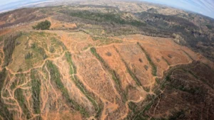
The environmental cost of the wall is a point of significant contention between federal agencies and conservation groups. The Chihuahuan Desert is an ecologically sensitive region, and the scale of the current project has led to visible changes in the landscape. Martinez and other observers have noted that hillsides once used for soil extraction are now heavily eroded. The constant movement of heavy vehicles has generated massive dust plumes that settle over native vegetation, potentially affecting photosynthesis and local air quality.
Furthermore, the physical barrier of the wall poses a challenge to wildlife migration. While the bollard design allows for the passage of very small animals, larger species such as javelina, mountain lions, and bighorn sheep find their historical corridors severed. This is particularly significant in the Bootheel, which serves as a biological bridge between the Sierra Madre of Mexico and the Rocky Mountains.
The Department of the Interior has argued that the wall actually protects the environment by preventing "unauthorized human activity," such as the creation of informal trails and trash left by migrants. However, critics like Congressman Gabe Vasquez (D-N.M.) have countered that the industrial footprint of the wall’s construction far outweighs the impact of foot traffic, calling the project a "definition of waste" that fails to address the root causes of migration while permanently scarring the land.
Socio-Economic Shifts in Local Communities
The influx of billions of dollars and thousands of workers has also transformed the social fabric of the region’s small towns. Hachita, New Mexico, a community that historically claimed fewer than 20 residents, has seen its population swell with the arrival of construction crews. The town, which consists of little more than a post office, a church, and a single gas station, has become a hub for "man camps"—temporary housing units for the laborers building the wall.
While this brings a temporary economic boost to local vendors, it also places a strain on limited infrastructure and alters the quiet, rural character of the area. For the "trail angels" and residents who have long supported the CDT hiking community, the shift from a recreation-based economy to a construction-based one represents a jarring transition.
Migration Data and Policy Analysis
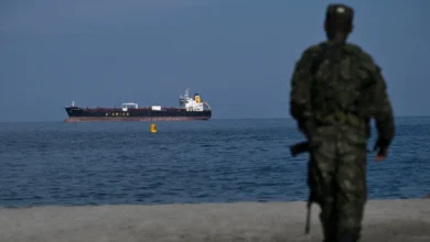
The justification for the emergency land transfer and the wall’s construction rests on border security data. According to CBP reports, the number of undocumented immigrants apprehended in the New Mexico and West Texas sectors saw a decline of 80 percent between 2025 and 2026. During this same period, the U.S. Army reported only 24 temporary detentions within the New Mexico NDA.
Proponents of the wall argue these statistics prove the effectiveness of a hardened border as a deterrent. They suggest that the mere presence of the infrastructure and the military jurisdiction of the NDA has funneled migration attempts away from these remote regions. Conversely, humanitarian organizations point to the extreme dangers of the Chihuahuan and Sonoran deserts. The United Nations has previously identified the U.S.-Mexico border as the world’s deadliest migration land route, with hundreds of deaths occurring annually due to heat exhaustion and dehydration. Critics argue that the wall does not stop migration but rather pushes it into even more treacherous terrain, increasing the likelihood of fatalities.
The Future of the Continental Divide Trail
As construction continues, the physical location of the CDT southern terminus is expected to change. To accommodate the two parallel barriers planned for the area, the Crazy Cook monument and the trailhead will likely be moved approximately 200 feet. While seemingly a small distance, the relocation symbolizes the broader displacement of the trail’s original spirit of "wildness."
For hikers like Leslie Boyd, who completed a southbound thru-hike during the height of the NDA confusion, the new reality of the border has led to a sense of protest. Boyd and a group of fellow hikers chose to bypass the official permit process, reaching the border via state trust land rather than submit to military authorization. By doing so, they forfeited the traditional photo at the Crazy Cook monument, opting instead to end their 3,100-mile journey at a simple barbed wire fence.
The long-term implications for the CDT remain uncertain. While the trail remains a destination for thousands, the "rugged solitude" that once defined its southern end has been replaced by the steel and surveillance of a modern border. As Martinez noted, the physical and spiritual loss of the landscape’s original state is something that may never be recovered, leaving a permanent mark on one of America’s most storied national trails.


